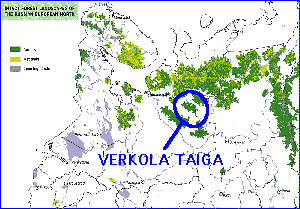
I've named this taiga area by an old and picturesque Verkola village, which is known by Russian writer F.A. Abramov and by it's monastery. I don't know what the area is called by locals or by officials. I only realised that it can be reached by train from Arkhangelsk to Karpogory (250 km) and then by car to Verkola (40 km). This massive taiga area begins virtually right from the end of the village street. We estimated that the area is about 7000 km^2.
 This map of North-West Russia is made by Russian and other NGO's
and represents the last intact taiga areas in NW Russia. Only areas bigger
than 500 km^2 were surveyed. Similar maps were first published by http://www.taigarescue.org/ in december
1999 and they inspired me to take this tour in July 2000. The aim of the
tour was to hike in a "real" taiga, larger than ever, and bring
this experience up to publicity. We still seem to think that there is mysterious,
endless taiga in Russia, but the truth is that it is rapidly disappearing.
We also witnessed some fresh first-growth clearcuts and road construction
near Verkola.
Verkola was chosen simply by easy and relatively "quick" access. It also looked like very typical taiga with flat topography and very few landmarks. We did not have maps from the Verkola area but we were lucky to get them from Arkhangelsk in one day, thanks to Arkhangelsk Forest Inventory Expedition and the city bookstore.
The trip itself took 4 days from Helsinki to Verkola, three nights in the train. We took the same way back in only 3 days since we did not spend a day in Arkhangelsk. In the taiga we spent 6 days.
